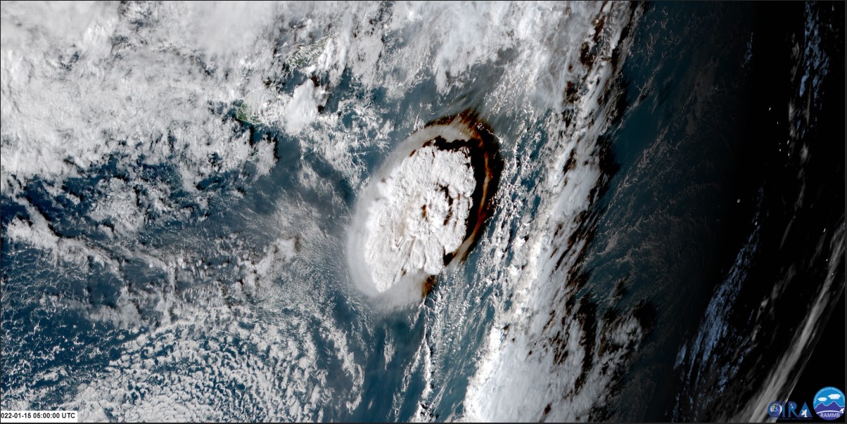
The Tonga Hunga volcanic eruption sent a tsunami across the Pacific. Air pressure disturbances from the tsunami distorted GPS signals. GOES imagery courtesy NOAA,NESDIS.
Anyone who’s ever lived along a coastline or been at sea knows the effects of tsunamis. And, they appreciate all the early warning they can get if one’s on the way. Now, NASA’s GNSS Upper Atmospheric Real-time Disaster and Alert Network (GUARDIAN) is using global navigation systems to measure the effect these ocean disturbances have on our atmosphere. The system’s measurements could provide a very effective early warning tool for people to get to higher ground in the path of a tsunami.
Earthquakes and undersea volcanic eruptions often trigger tsunamis. Essentially, those tectonic events displace huge amounts of ocean water. During the resulting tsunami, huge areas of the ocean’s surface rise and fall. As they do, the ocean movement displaces the overlying column of air. That sets off ripples in the atmosphere. Think of it as if the air is responding by creating its own tsunami. It actually does that in response to fast-moving storms and their squall lines. Meteorologists call those reactions “meteotsunamis.” They can push water around into dangerous waves, which then cause flooding and other damage. That’s very similar to tsunamis generated by earthquakes.
What NASA’s Doing to Predict Tsunamis
Weather forecasters can generally predict bad weather leading to meteotsunamis, but that’s not the case for earthquakes and underwater volcanoes and the tsunamis they trigger. So, the NASA project aims to provide advance notice after a temblor or a volcanic eruption.
The GUARDIAN system taps into a constant data stream emitted by clusters of global positioning satellites and other wayfinding stations orbiting Earth. They give real-time information about changes in water heights in the ocean and surface measurements of land masses. Those data-rich radio signals get collected by ground stations and sent to NASA Jet Propulsion Laboratory. There, it gets analyzed by the Global Differential network, which constantly improves the real-time positional accuracy of features on the planet.
So, when a tectonic event happens, the system is alerted to look for changes in the air masses over the oceans. Displaced ripples in the air move out in all directions as low-frequency sound and gravity waves. Those vibrations rush to the top of the atmosphere within just a few minutes. There, they crash into the charged particles of the ionosphere. That distorts signals from the GPS satellites, and those distorted signals tell the system that something’s going on down below.
This animation shows how waves of energy from the Tohoku-Oki earthquake and tsunami of March 11, 2011, pierced Earth’s ionosphere in the vicinity of Japan, disturbing the density of electrons. These disturbances were monitored by tracking GPS signals between satellites and ground receivers.Credits: NASA/JPL-Caltech
Normally navigational systems would correct for the distorted signals because they aren’t useful to their users, according to Léo Martire, who works on the GUARDIAN project. “Instead of correcting for this as an error, we use it as data to find natural hazards,” he said.
Early Warning is the Key
The most active tectonic region on our planet is the area known as the Ring of Fire. It’s basically a large ring of volcanically and tectonically active regions in the Pacific Ocean basin. About 78 percent of tsunamis between 1900 and 2015 occurred there.
Most of us remember the tsunami that hit Japan after a magnitude 9.0 earthquake hit just off the coast in 2011. That event devastated 70 kilometers of coastline, destroyed towns and villages, 𝓀𝒾𝓁𝓁ed hundreds of people, and shut down the Fukushima nuclear power plant.
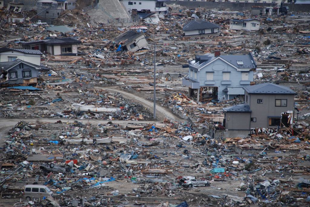
Damaged village in Japan in the wake of the tsunami onf 2011. Photo: Katherine Mueller, IFRC
One of the most damaging tsunamis occurred on the Big Island of Hawai’i on April 1st, 1946. An earthquake off the Aleutian Islands triggered the tsunami that crushed a small village in Alaska and struck California. It also reached out and touched the Hawaiian coast near Hilo. 50-foot waves crashed into the island, taking out buildings, and bridges, and 𝓀𝒾𝓁𝓁ing 159 people.
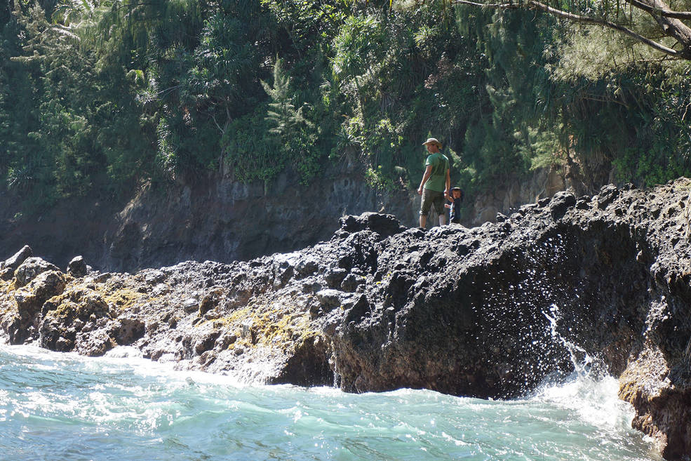
The 1946 tsunami generated huge waves that hit this area near Onomea Bay on the Big Island. Credit: M. Younger.
Volcanic eruptions also trigger these waves. The Tonga eruption of January 15, 2022, sent a tsunami out across the Pacific and disrupted the atmosphere, which affected satellites around the world.
GUARDIAN and the Ring of Fire
With potential damages like these and others, it’s no wonder scientists look for ways to predict those events. “When there is a large earthquake near the ocean, we want to quickly know the magnitude and characteristics of the earthquake to understand the likelihood that a tsunami will be generated, and we want to know if a tsunami was indeed generated,” said Gerald Bawden, the program scientist for Earth’s Surface and Interior at NASA Headquarters in Washington. “Today there are two ways to know if a tsunami was generated before it makes landfall—NOAA’s DART buoys and GNSS-ionosphere observations. There is a limited number of buoys and they are very expensive, so systems like GUARDIAN have the potential to complement current warning systems.”
At the moment, the GUARDIAN project is using the Pacific Ocean as a testbed for the early warning system. GPS measurements measure the displacements in the atmosphere. The project created a website where experts can look up the state of the ionosphere in real time. There’s data from about 90 stations situated around the Ring of Fire, and any signals from events show up nearly instantaneously. Eventually, the system should be useful for events occurring around the world, wherever a tectonic event disrupts sea, land, and atmosphere.